
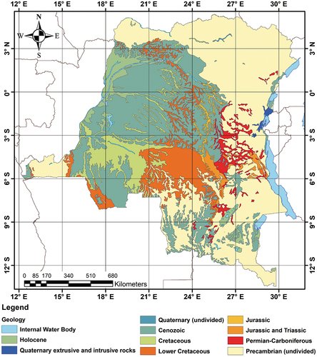
D.R. Congo Decides the Map Is Worth More Than the Mine: A National Geological Data Bank and a Nationwide Airborne Survey
Summary
September announcement: on 8 September 2026, SGNC director general Raoul Wazenga Vitima said Congo is building a national geological data bank, calling the data "a strategic asset of the Congolese state". Access will be tiered: basic data free, sensitive data fee-based, with requests screened against investor needs and Congo's strategic interests.
The engine: a US$180 million, three-year contract with Spain's Xcalibur, running since January, covers more than 700,000 km². Partners include BRGM (France), the Council for Geoscience (South Africa), KoBold Metals and Atlas Park (both US), and Solafune (Japan).
October rollout: PC2G-RDC launched in Kinshasa on 5 October (reported on 6 October). It will deploy eight aircraft over 36 months to raise modern geoscientific coverage from 22.27% to 46.1%, funded by the Mining Fund for Future Generations, starting in Kongo Central, Kwango, Kwilu and Greater Kasai.
Coverage figures: 22.27% is modern geoscience coverage; officials say less than 10% of mineral-rich land has been fully explored. They measure different things.
The US angle: US firms are pushing to map Congo, and KoBold has published 260,000 pages of historical records as open data, a model in tension with the SGNC's fee tiers.
The law: data ownership, access discretion, non-discrimination under the US partnership, and the mining code bill's provisions on strategic minerals and state stockpiles.
September: Congo Claims Its Geological Data
The announcement. On 8 September 2026, Raoul Wazenga Vitima, director general of the National Geological Survey of Congo (SGNC), told Reuters that Congo is accelerating geological mapping, airborne surveys and the digitisation of historical archives to build a national geological data bank on its critical minerals. The data bank is expected to be fully operational by the end of 2026.
The principle. Vitima put the policy in one sentence: "The data generated under these programmes constitute a strategic asset of the Congolese state."
How access will work:
Element | What the SGNC has said |
|---|---|
Tiered access | Basic geological information free of charge |
Fees | Access to more sensitive datasets will be fee-based. The fee structure and the categories of data to be charged have not been specified |
Screening | Requests will be assessed against both investor needs and the protection of Congo's "strategic interests" |
Neutrality | The data bank is not meant to favour China or the United States; the same access rules are to apply to all companies, regardless of origin |
Revenue use | Fees from certain data products will help fund continued exploration and mapping |
Precedent | Similar fee-based models exist in Tanzania and South Africa |
Why now. The SGNC estimates that systematic exploration covers barely 20% of the country. Vitima argued that established mining jurisdictions generated much of their geological data decades ago and have already benefited from its commercial use. Congo, he suggested, should capture that value itself rather than leave it to others. Reuters, which based its report on an official and seven industry sources, noted that some analysts consider the move potentially more significant than the cobalt export policies that reshaped the global market.
The Machinery: Who Is Mapping Congo
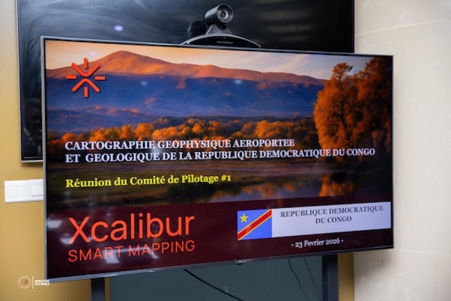
The main engine: Xcalibur. The centrepiece is a US$180 million, three-year contract with Spain's Xcalibur Multiphysics Group, which began in January 2026. It covers more than 700,000 km² using airborne geophysics, digitised data and advanced analytics to identify exploration targets in unexplored areas. Xcalibur is also mapping Saudi Arabia, and Congo is sharing its experience with Riyadh as the kingdom diversifies into mining.
A crowded field of partners:
Partner | Origin | Role |
|---|---|---|
Xcalibur | Spain | National airborne survey contract (US$180 million, three years) |
BRGM | France (state geological survey) | Mapping partnership |
Council for Geoscience | South Africa | Mapping partnership |
KoBold Metals | United States | Digitisation of historical archives; exploration data; lithium exploration around Manono |
Atlas Park | United States | Five-year agreement, signed at Mining Indaba in February 2026, for AI-driven mapping using historical data and new surveys; findings shared with the SGNC |
Solafune | Japan | AI-based mapping support and training of Congolese experts |
AfricaMuseum | Belgium | Holds colonial-era geological archives |
The US push. On 13 July 2026, Semafor reported that a US aviation firm, Dynamic, was preparing a proposal to collect geological data in Congo, joining Xcalibur and Atlas Park. Washington wants US firms positioned in Congo's mineral sector as competition with China intensifies; Chinese companies control up to 80% of Congo's critical-mineral production. Dynamic and Xcalibur said the data they collect would belong to the Congolese government, while Atlas Park's findings are to be shared with the SGNC.
The archive question. Much of Congo's historical geological record sits in Belgium's AfricaMuseum. In 2025, Congo and KoBold agreed to cooperate on free public access to historical geoscience data through the SGNC, with KoBold digitising the archives. Belgium's science minister insisted that KoBold could not take possession of original documents because Belgium had not signed the agreement. KoBold says it has since made more than 260,000 pages of Congo's historical geological records publicly available, and its Congo head says its objective is "open data for explorers and researchers".
A tension to watch. KoBold's open-data approach sits uneasily with the SGNC's planned fee-based tiers. Which historical data stays free, and which new survey data is charged for, will shape how the two models coexist.
October: PC2G-RDC Takes Off
The launch. Congo launched the operational phase of the second stage of its airborne geophysical and geological mapping programme, PC2G-RDC, in Kinshasa on Monday 5 October 2026. Most international outlets reported it on 6 October.
Element | Detail |
|---|---|
Programme | PC2G-RDC, second stage of Congo's national airborne geophysical and geological mapping programme |
Duration | 36 months |
Coverage target | Raise national geoscientific coverage from 22.27% to 46.1% |
Equipment | Eight aircraft collecting high-resolution magnetic, radiometric, gravimetric and electromagnetic data, followed by processing, interpretation and field geology |
Coordinator | National Geological Survey of Congo (SGNC), under the Mines Ministry |
Contractor | Xcalibur Multiphysics Group |
Funding | Mining Fund for Future Generations (FOMIN), a public fund that manages part of Congo's mining revenues for future generations |
First regions | Kongo Central, Kwango, Kwilu and Greater Kasai, building on surveys already completed in Greater Katanga, the copper-cobalt heartland |
The political message. Mines Minister Louis Watum Kabamba framed the programme as a matter of sovereignty, saying that sovereignty does not begin when a mineral is extracted. The SGNC put it plainly: "Congo should not only be better mapped; it should increasingly be capable of mapping itself."
Two coverage figures, two different measures. Readers will see two numbers in coverage of the launch. They are not in conflict:
Figure | Source | What it measures |
|---|---|---|
22.27% → 46.1% | PC2G-RDC programme, cited by the Mines Minister | Share of Congo's territory covered by modern geoscientific data (airborne geophysics and related mapping) |
Less than 10% | Officials, as reported by Reuters at the launch | Share of Congo's mineral-rich land that has been fully explored |
About 20% | SGNC estimate, September | Share of the country covered by systematic exploration |
Modern airborne coverage tells explorers where to look. Full exploration, with drilling and resource definition, is far narrower. Doubling the first is meant to accelerate the second.
Funding from mining rents. Paying for the survey from FOMIN, rather than relying solely on foreign partners, matters to the sovereignty argument. It means the state owns what it has paid for, and has a stronger legal and political basis to control access and charge for it.
Who Owns the Map? The Legal and Strategic Questions
1. Data as a state asset
Congo's position is that geological data generated under national programmes belongs to the state. That follows naturally where the state pays, as with FOMIN funding for PC2G-RDC, and where contractors such as Xcalibur and Dynamic have said the data they collect belongs to the government. It is less straightforward for:
historical archives held abroad, such as those in Belgium's AfricaMuseum, where custody is disputed;
private exploration data generated by licence holders at their own cost, which mining law typically requires to be reported to the state but may also protect for a confidentiality period; and
processed and interpreted products, such as models and targets, where contractor and partner agreements decide who owns the analysis.
The data bank's legal framework, including access rules, confidentiality periods and fee schedules, has not yet been published. It will need to answer each of these questions.
2. Discretion and non-discrimination
Access requests will be weighed against investor needs and Congo's "strategic interests". That gives the SGNC significant discretion. The SGNC has said the same rules will apply to all companies regardless of origin, but the US–Congo strategic minerals partnership includes a right of first offer for US firms on designated assets, and several US companies are mapping partners. Investors will watch whether early or preferential access to data flows to partners, or whether the tiered system is applied evenly. Published criteria and decisions would reduce the risk of disputes and of claims under investment treaties.
3. Links to the mining code overhaul
The pending bill to amend more than 40 articles of the 2018 Mining Code would expand state control over strategic minerals and allow state stockpiles. A state that controls geological data, ARECOMS export quotas, strategic-mineral royalties and potentially stockpiles would hold levers over every stage, from discovery to export. The data bank is the earliest of those levers: it shapes where exploration capital goes before any licence is granted.
4. Open data versus paid data
International practice varies. Many geological surveys publish regional geophysics freely to attract exploration, and charge only for detailed products or services. Tanzania and South Africa, cited by the SGNC, use fee-based models. KoBold, by contrast, has published historical records as open data. The design question for Congo is where to draw the line. Charging too much, or screening too heavily, could deter the explorers the programme is meant to attract.
5. Data as industrial policy
As one mining technology executive told Reuters, unlike export controls, geological data influences future supply, and whoever controls the best information often influences where exploration capital flows next. Congo is attempting to move from regulating the minerals already coming out of the ground to shaping which deposits are found and developed in the first place.
What It Means for Each Stakeholder
Junior explorers and new entrants
The opportunity: modern airborne coverage across Kongo Central, Kwango, Kwilu and Greater Kasai lowers the cost and risk of finding targets outside the Copperbelt. That helps companies without decades of proprietary data. The worry: fees and screening. Budget for data purchases, prepare to justify access requests, and watch for any preference given to partners.
Established producers
Companies with deep proprietary datasets in Greater Katanga lose part of their information advantage as the state publishes or sells modern data. They should review their own reporting obligations to the SGNC, confidentiality protections for their exploration data, and how their data might enter the national bank.
US-linked investors and the minerals partnership
KoBold, Atlas Park and potential new entrants such as Dynamic are deeply involved in mapping. Whether that involvement brings early access, or whether Congo enforces the same rules for all, will be a test of both the data bank and the US partnership.
Chinese companies
Chinese firms control up to 80% of Congo's critical-mineral production. Equal access rules would protect their ability to compete for new discoveries; any perceived tilt towards Western partners could become a commercial and diplomatic issue.
Mapping contractors and geoscience firms
Xcalibur's contract and the PC2G-RDC rollout create demand for airborne survey, processing and interpretation services. Contracts will need clear terms on data ownership, confidentiality and transfer of skills, given the stated goal that Congo should be able to map itself.
The Congolese state and SGNC
The state gains a strategic asset and a potential revenue stream, and can steer exploration towards under-explored provinces. The challenges are capacity, keeping the data secure and up to date, and designing fees and access rules that attract rather than deter investment.
Provincial governments and communities
New mapping in Kongo Central, Kwango, Kwilu and Greater Kasai may bring exploration activity to regions with little mining history. Early engagement on land rights, community consent and benefit sharing will matter.
Lawyers and advisers
The work includes data access agreements, licence conditions and confidentiality of exploration data, ownership of processed data under partner contracts, and assessment of discrimination risk under the US partnership and investment treaties.
Key Dates
Date | Event |
|---|---|
2025 | Congo and KoBold agree to cooperate on free public access to historical geoscience data; Belgium disputes custody of the archives |
January 2026 | US$180 million, three-year Xcalibur contract begins |
February 2026 | Atlas Park signs five-year AI mapping agreement at Mining Indaba |
13 July 2026 | Semafor reports US firms stepping up their push to map Congo |
8 September 2026 | SGNC announces the national data bank and tiered fee model |
5–6 October 2026 | PC2G-RDC launched in Kinshasa and reported internationally |
End of 2026 | National data bank expected to be fully operational |
What to Watch
Milestone | Why it matters |
|---|---|
Fee schedule and access rules | What is free, what is charged, and how "strategic interests" screening works |
Treatment of US-linked partners | Whether the minerals partnership brings early or preferential data access |
Mining code bill | How data control fits with state stockpiles and expanded control over strategic minerals |
PC2G-RDC progress | First data releases from Kongo Central, Kwango, Kwilu and Greater Kasai |
AfricaMuseum archives | Whether custody and access to colonial-era records are resolved |
Frequently Asked Questions
What is Congo's national geological data bank? A state-controlled repository of geological data from mapping, airborne surveys and digitised archives, expected to be fully operational by the end of 2026, with tiered access: basic data free and sensitive data for a fee.
What is PC2G-RDC? A 36-month nationwide airborne geophysical and geological mapping programme launched in October 2026. It is funded by the Mining Fund for Future Generations, executed by Xcalibur, and aims to raise modern geoscientific coverage from 22.27% to 46.1%.
Who is mapping Congo? Xcalibur (Spain) under a US$180 million contract, with partnerships involving France's BRGM, South Africa's Council for Geoscience, US-based KoBold Metals and Atlas Park, and Japan's Solafune.
How much of Congo has been explored? The answer depends on the measure. About 22.27% of the country has modern geoscientific coverage, the SGNC estimates about 20% has systematic exploration, and officials say less than 10% of mineral-rich land has been fully explored.
Will Congo charge for geological data? Yes, for more sensitive datasets. Basic information will be free. The fee structure has not been published.
Citations
- 1.• Congo extends state control over mining with bid to lock down geological data, Reuters via Mining Weekly (8 September 2026)
- 2.• Congo extends state control over mining with bid to lock down geological data, Reuters via CNBC Africa
- 3.• DRC launches national databank for critical mineral mapping, Sowetan (8 September 2026)
- 4.• Congo launches geological survey in push to unlock mineral potential, Reuters via Mining Weekly (6 October 2026)
- 5.• DRC Launches 36-Month Push to Double Geological Mapping Coverage, Bankable (6 October 2026)
- 6.• DRC Launches 36-Month Airborne Geological Mapping Programme, SMM (6 October 2026)
- 7.• DRC launches nationwide geological mapping program, Mining.com.au (7 October 2026)
- 8.• RDC : cartographier le sous-sol pour mieux valoriser les ressources, CongoQuotidien (6 October 2026)
- 9.• US firms step up push for DR Congo mining maps, Semafor (13 July 2026)
- 10.• DR Congo inks AI deal with US firm to map country's critical minerals, Semafor (11 February 2026)
- 11.• In Congo, US mining company fights for subsoil data held in Belgium museum, The EastAfrican
- 12.• DRC Taps U.S.' Kobold and Japan's Solafune to Boost Geological Data Access, Bankable
Finish Reading the Full Story and Expert Analysis.
Get the latest legal & regulatory intelligence in DR Congo
Wansom is AI and can make mistakes.